Southwater, Crabtree, Shermanbury, Knepp Loop
Introduction
Southwater, Crabtree, Shermanbury, Knepp Loop is a 39.3km circular route with an astonishing 1,600ft of ascent. Don’t be put off; while there are many little climbs, they are normally short and not too steep. The route explores some lovely areas of the Sussex countryside, covering picturesque woodland environments, the flood plains of the Adur Valley, often teeming with deer in the summer months, and the wildlife rich Knepp estate. There are plenty of places to stop en-route for beer, cake or coffee and this is a fantastic route in the summer months when the bridleways have drained and are at their best!
Southwater, Crabtree, Shermanbury, Knepp Loop
A 39km mix of road and bridleways; winding through the West Sussex countryside. In the wetter months the bridleways can become bogged down, so this route is recommended in the dry seasons. There are plenty of places to stop for refreshments and scenery throughout the route.
30 Apr 2022
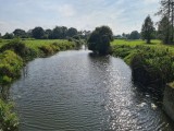
Southwater Country Park
The route starts at the Southwater Country Park. There's plenty of parking (pay to park), but it can get busy in the summer months. There is a cafe and toilets on site.
The South Downs Link passes between the main car park and the park itself [there are other car parks, so make sure you’re in the right one], it should be easy to find, but if not, just ask someone to point it out. After you exit the park, cross Cripplegate Lane and continue to follow the Downs Link southward. After the little tunnel under the A24, the tarmac road turns through 90 degrees to the left and the Downs Link branches off to the right.
Continue to follow the Downs Link through a wooded section where it leads to Copsale and meets Bar Lane. Turn left, off the Downs Link and follow Bar Lane until the next junction where you need to turn left onto Broadwater Lane. Follow this lane for about 500m, passing the junction to Polecat Lane on the left; keep an eye open for a bridleway sign on the right, just before some cottages. The bridleway climbs up into a field, easily missed but obvious when you see it.
Elliotts
Continue to follow the bridleway along the edge of the field where it then enters a wooded section. Follow this all the way along, down a little dip, over a little bridge and up alongside another field until you meet a gate. Pass through the gate and directly across the field where you’ll pass another gate and enter Elliotts and Elliotts Farm. Keep going in straight line along the tarmac road, straight through the farm and out the other side, don’t turn left or right, keep going in an easterly direction. The bridleway then follows a hedge (that should be on your left), then crosses through a gap leaving the hedge on your right. Continue to follow this down the gentle hill where it crosses a track (horse racing?) and enters a wooded section.
Nuthurst
Continue to follow the bridleway, which generally follows the course of a little stream passing through woodland and fields where it then meets the lane of Nuthurst Street [this section can get pretty boggy during wetter periods]. Turn left and follow the road into the village of Nurthurst. Keep an eye open for a bridleway sign on the right – it’s opposite the entrance to St. Andrews Parish Church; if you reach the Black Horse pub you’ve gone too far [but it is a very nice pub].
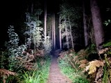
Follow the lane past the old garden centre around a left turn then up a steep right – take care not to go into the private grounds; it’s all signed, so just follow the bridleway signs [basically keep to the right!]. After you’ve passed some slightly rundown buildings, the track enters a wooded section; keep right of the cottage at the end and continue to follow the bridleway uphill through this lovely section of coniferous woodland [Lodgesale Wood], passing a cutting for some power cables before it once again meets a lane (Newells Lane). Do a left turn onto the lane then almost immediately right, back onto another bridleway.
Follow this gravelled bridleway slightly downhill. Where it bends off to the left, turn right [signed bridleway], onto a mud surface and continue to follow the bridleway through a wooded section slowly descending downhill. You may glimpse some ponds through the trees on the right before you cross a little Gill at the very bottom [often very muddy] and ascend a steep but short climb up the other side. Continue to follow this bridleway [ignore the first track to the left that leads into a field], until you reach a junction. Do a sharp turn to the left [signed bridleway], and continue to climb up out of this little valley where you’ll meet a gravel track towards the top. Turn left and continue up towards the A281. Through the trees on the right, you may be able to glimpse the South Lodge hotel.
Crabtree
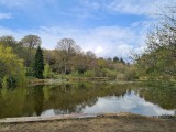
Once at the A281, cross very carefully [the view is a little obscured] and turn right and continue down the hill until you see the Mill Lane on the left, turn left onto Mill Lane and follow this all the way along, where is veers towards the south and becomes a gravel track. Go down the hill until you see a house on the left towards, but not quite all the way at the bottom. Just past the house is a gate on the left with a bridleway sign. Go through this gate and follow the hedge on your left down the field to the bottom. Go through the gate where you’ll be rewarded with a lovely view across a pond [Pond Bay] and the lower part of Leonardslee Gardens.
Steep Wood
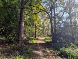
Continue to follow the bridleway past the lake around a right turn and up a short hill. This part of the track is almost always muddy. Follow the bridleway as it undulates through this beautiful woodland [Steep Wood], being careful not to stray off on the footpath that branches off from the bridleway. After the final climb the bridleway meets Spronkett’s Lane. Turn left and continue for 100 metres until the bridleway on the right. Enjoy a zoom down this bridleway where it eventually re-emerges on Spronkett’s Lane at the bottom of the hill [via Earwig Lane and Cross Colwood Lane].
The character of the ride now changes as you start to descend towards the River Adur. The next few kilometres are on quiet country lanes. Continue to follow Spronkett’s Lane, up then down the hill then turn right onto Bull's Lane. At the end turn left on to Picts Lane and follow this all the way to the A272. Cross the A272 carefully and follow Kent Street; you’re now looking for the second bridleway signed on the right, it’s just past the houses on the right at the top of a small hill.
Shermanbury Place
Follow this bridleway all the way through to the end where it joins Fryland Lane. Follow this in a southerly direction and when it turns 90 degrees to the left, continue straight on onto the next bridleway. Follow this track for about 400m where the bridleway continues from a left branch off the track. Continue all the way along this bridleway which follows the River Adur off to the left. Eventually, the bridleway opens and passes some houses and St. Giles Church on the left.
Continue to follow the bridleway until it meets the A281 where an iron gate can be found. Use the little iron gate on the right if the main gate is closed/locked . Turn right [careful as you go as cars speed around this corner] and follow the A281 northward towards Partridge Green. AFter about a kilometre, follow the signs to Partridge Green by turning left off the A281 onto the Partridge Green Road.
Continue through the village until you meet a the T-junction, turn left on to the B2135, up over the old railway bridge then turn right into Lock Lane, also signed as a bridleway. Alternatively, to cut the route short [this is approximately half way around], join the Downs Link [it's very clearly signed in Partridge Green] and follow it northward back to the Southwater Country Park.
Follow this lane, crossing the River Adur and start to ride up the hill. About halfway up is a bridgeway sign on the right; follow the sign onto the bridleway, crossing a track and passing through a farmyard [Lock Farm]. Keep going straight until you see the next bridgeway sign pointing right and exiting the farm. Exit the farm here and turn right onto the gravel track which shortly bends to the left headed in a westerly direction.
Continue to follow this bridleway for approximately 3km; it’s easy to veer off the bridleway, so keep an eye open for the bridleway signs. Eventually you’ll meet Grinder’s Lane where you turn right heading towards the A24 dual carriage way and passing the Old Barn Nursey on the left - feel free to pop in for a coffee/cake or something more substantial if required!
Dial Post
Cross the A24 very, very carefully and head into the village of Dial Post along Worthing Road. Follow this for about a kilometre until you see a bridleway sign on the left, directing down Bentons Lane. Head off down Bentons Lane towards Knepp Estate.
Knepp Estate
Knepp Estate is one of West Sussex’s hidden little gems. In 2021 the main bridleway running northward through the estate was vastly improved, and can now be ridden pretty much most of the year. Follow Bentons Lane, crossing a cattle grid headed towards Bentons Place Farm. Not too far off this bridleway are the famous storks of Knepp Estate; follow the bridleway until just before Bentons Place Farm. There is a permissive track to the right that avoids going through Bentons Place, take this, passing a little pond before entering a wooded section. Continue along the bridleway where it meets the main bridleway running north/south through Knepp Estate. Turn right onto this bridleway, pass through the large gate and continue northward. Keep your eyes open along here, you’ll almost always see some wildlife. Keep a lookout for a tree house too; it’s always worth popping up there on a quiet day!
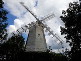
Shipley Windmill
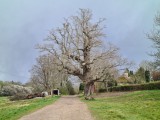
After 2 kilometres along this bridleway, you’ll meet another large gate that leans onto Countryman Lane. Turn right onto the lane then shortly left onto the next bridleway. Follow this down the hill, crossing the River Adur again then up the hill where you’ll find Shipley Windmill on the right. Continue to follow the bridleway where it meets School Lane. Turn left onto School Lane following past Shipley Primary school on the left, up the hill, around the left bend where shortly after, the bridleway on the right needs to be taken. Ride this bridleway for 500m where it emerges on the A272.
Cross the A272 cautiously and head off down Dragons Lane. After the bend, take Dragons Green Road and continue up the hill. As an alternative and to avoid road riding, look for the first bridleway on the right – it’s normally pretty wet and muddy down here [most of the time], but when it eventually dries out, it’s quite pleasant! If not, continue on Dragons Green Road looking for the next bridleway on the right. Take this into Marlpost Wood, dropping down the hill, around the bend and up the other side. Follow the bridleway around to the right, then through the trees on the left. You’ll pass some gardens, one with a pool in the back garden. Continue through this little collection of houses [making sure to spot and follow the bridleway signs], following Shaw’s Lane all the way to the end where it meets Bonfire Hill. Turn right continuing up the hill, around the right turn at the top where the road becomes Church Lane. As you start accelerating down the hill into the village, take the left turn into Southwater Sports Club and follow it through towards the football pitches, where it eventually connects with the Downs Link.
Turn right onto the Downs Link for the home stretch back into the village of Southwater, passing the village shops and surgery all the way back to the start at Southwater Country Park.